Prof. Jason P. Evans
Climate Change Research Centre
University of New South Wales


Review of Drought in the Middle East and Southwest Asia.
Barlow, M., B. Zaitchik, S. Paz, E. Black, J. Evans and A. Hoell
Journal of Climate, doi: 10.1175/JCLI-D-13-00692.1, 2015.
Abstract
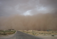
The Middle East and Southwest Asia comprise a region that is water-stressed, societally vulnerable, and prone to severe droughts. Large-scale climate variability, particularly La Niña, appears to play an important role in region-wide drought, including the two most severe of the last fifty years—1999-2001 and 2007-2008—with implications for drought forecasting. Important dynamical factors include orography, thermodynamic influence on vertical motion, storm track changes, and moisture transport. Vegetation in the region is strongly impacted by drought and may provide an important feedback mechanism. In future projections, drying of the eastern Mediterranean is a robust feature, as are temperature increases throughout the region, which will affect evaporation and the timing and intensity of snowmelt. Vegetation feedbacks may become more important in a warming climate.
There are a wide range of outstanding issues for understanding, monitoring, and predicting drought in the region, including: dynamics of the regional storm track, the relative importance of the range of dynamical mechanisms related to drought, regional coherence of drought, the relationship between synoptic-scale mechanisms and drought, predictability of vegetation and crop yields, stability of remote influences, data uncertainty, and the role of temperature. Development of a regional framework for cooperative work and dissemination of information and existing forecasts would speed understanding and make better use of available information. Key Figure Figure 4. a) Annual mean precipitation, b) elevation, c) growing season vegetation, and d) coefficient of variation for annual precipitation (ratio of the standard deviation to the mean). The contour intervals for precipitation and elevation are 10cm and 0.5km, respectively. The growing season vegetation is estimated by Apr-Aug Normalized Difference Vegetation Index (NDVI). Both NDVI and the coefficient of variation are unitless ratios, with contour intervals of 0.1 in both cases. The NDVI is shaded from light green (least vegetative vigor) to red (most vigor), to allow visual discrimination of the large range in vegetative vigor over the region. The GPCC version 6 dataset (Schneider et al. 2013, Rudolf et al. 2003) is used for precipitation, with the averaged calculated for the 1951-2010 period, the GIMMS NDVIg dataset (Pinzon et al. 2005, Tucker et al. 2005), produced by the Global Land Cover Facility (GLCF) at the University of Maryland – College Park, is used for NDVI, for the1981-2006 period, and the ETOPO5 dataset (NOAA National Geophysical Data Center, 1988) is used for topography. |
|