Prof. Jason P. Evans
Climate Change Research Centre
University of New South Wales


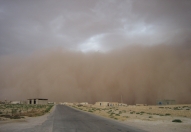


WRF can simulate recent fire weather in southeast Australia.
Clarke, H., J.P. Evans and A. Pitman
Annual conference of the Australian Meteorological and Oceanographic Society (AMOS) 2012, Sydney Australia, 31 Jan – 3 Feb 2012. Abstract
The climate of southeast Australia has been simulated using the Weather Research and Forecasting (WRF)
model. WRF was implemented using both a 10 km and 50 km horizontal grid and run for 25 years from
1985-2009. The National Oceanic and Atmospheric Administration Centers for Environmental Prediction
(NCEP) / National Centre for Atmospheric Research (NCAR) reanalysis supplied the lateral boundary
conditions. The model simulated climate was evaluated against station-based observations of the McArthur
Forest Fire Danger Index (FFDI), an index used to predict the likelihood of putting out any fires which may
occur. WRF was evaluated at daily, monthly and seasonal timescales against measures of average and
extreme FFDI, as well as variability in FFDI. WRF showed skill in simulating the main features of the FFDI
distribution and their spatiotemporal variation. Biases in the model simulated climate were biggest at the
uppermost values of the FFDI distribution e.g. days above 50. Increasing the resolution from 50 km to 10 km
improved the performance of the simulations in most cases, although often only marginally. The skill shown
by WRF in simulating regional climate in southeast Australia suggests it is suitable for use in downscaling
projections from global climate models for this part of the world, provided that known biases in simulating
extreme values are taken into account.
|
|