Prof. Jason P. Evans
Climate Change Research Centre
University of New South Wales


|
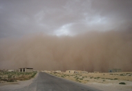
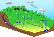
This project is part of the Eastern Seaboard Climate Change Initiative (ESCCI) sponsored by the NSW government Office of Environment and Heritage. The focus of this project is to use relatively high resolution (10km) regional climate model simulations to investigate how the frequency and intensity of East Coast Lows may change in the future due to global warming. These storm systems often develop quickly and can remain relatively small spatially, making them difficult for global models to capture. The project will also attempt to quantify the influence of local topography and sea surface temperatures on the East Coast Lows. Sub-daily precipitation extremes This project is an international collaboration initiated by the GEWEX Hydroclimate Panel. Several studies have used local data to show that sub-daily precipitation extremes can be intensifying even if at daily and longer time-scales this is not the case. This project is aiming to bring together a large dataset of high quality sub-daily precipitation from around the globe. Trends in this sub-daily precipitation can then be investigated globally including questions around mechanistic causes and model capabilities. This project focuses on land-atmosphere interactions in the Murray-Darling Basin. I am attempting to answer questions concerning the effects of land-atmosphere feedbacks on precipitation in the watershed. What is the extent of precipitation recylcing in the MDB? Where is the land-atmosphere interaction strongest? The major tool for this study is a regional climate model. In this case I am using a version of the Weather Research and Forecasting (WRF) model. This work contributes to the Australian Energy and Water Exchanges initiative (OzEWEX). In order to quantify the impact of a mountain range on the incoming atmospheric water vapor we examined the stable isotope ratios of hydrogen and oxygen in streams and twigs an the lee side of a mountain range. When compared with the isotopic ratios of the incoming airmass it is possible to calculate the proportion of water vapor rained out as it passes the range, or the "Drying ratio". Regional climate of the Middle East As part of the South-West Asia Project (SWAP) I have been attempting to model the present day climate of the region. Various investigations into the effects of changes in land-use, drought - vegetation feedacks, and the transport and sources of water vapor etc have been conducted. Experiments looking into the future (ie. global warming scenarios), quantifying the predicted impact on precipitation and temperature, changes in precipitation processes and water vapor transport. Regional climate modelling I have been investigating the ability of several regional climate models to reproduce the current energy and water balances over multi-annual time scales. The models (RegCM2, MM5/BATS, MM5/SHEELS, MM5/OSU) have been applied over central USA. The domain is centered over the FIFE region in Kansas where an intensive field experiment was conducted and extensive data is available for evaluation of the models. While no model consistently performed better then the other models it was found that during 'normal' conditions the various land-surface schemes performed similarly but under stressed conditions (eg. unusually dry) they behaved quite differently. While the atmospheric radiation and precipitation parameterizations were important in determining the driving forces at the surface, differences in the transfer of momentum (eg. surface winds and drag coefficients) played a major role in determining the split between latent and sensible heat. Using numerical weather models we investigate the influence of topography on the initiation and continuation of precipitation events. This was done over the European Alps in cooperation with the Mesoscale Alpine Project (MAP). I have been involved in studies looking at identifying relationships between catchment characteristics and in-stream phosphorus. These studies used reasonably large in-stream phosphorus data sets collected in the Goulburn-Broken basin in South East Australia. Slope and intensive agriculture within 500m of the stream seem to be the two most important catchment characteristics observed to date. Much of the work I have done involves hydrological modelling of some sort. The rainfall-runoff model I have used most is IHACRES. It is a lumped conceptual model which has minimum data requirements (rainfall, streamflow and temperature) and only a small number of parameters (~7). This model has been applied in many places around the world, under many different climatic conditions often performing better than more complex models. I have applied it successfully to many catchments, from temperate, humid catchments in South East Australia to semi-arid catchments in inland New South Wales (NSW), Australia to tropical monsoonal catchments of northern Thailand. Land surface/atmosphere Interaction modelling Much of the hydrological modelling has been concerned with the climates effect on the surface hydrology, of particular interest here is the feedback to the climate from the land surface hydrology. This interaction is given by the exchange of energy and water fluxes at the surface. Both of these fluxes are embodied (to a large extent) in the evaporative flux. In order to investigate this interaction a new version of IHACRES was developed which explicitly calculated the evaporation each time step without requiring extra data and keeping the number of parameters to a minimum. The model is based on the catchment moisture deficit (CMD) which is a measure of how far from saturation a catchment is. CMD-IHACRES has been extensively tested and shown to provide streamflow results as good as IHACRES while still providing the evaporation estimates. The model structure also allows evaporation and streamflow to be dealt with using different time steps. The impacts of climate change on streamflows has been investigated using different techniques. Around Perth, Australia results from a Global Climate Model (GCM) were spatially downscaled and temporally extended using a stochastic weather generator. This created climatic time series was then used in conjunction with CMD-IHACRES to provide estimates of the streamflow response to the climate change. Also in the Middle East, GCM results were downscaled using a regional climate model enabling investigation into changing precipitation processes and water vapor transport. A study into the effects of increasing numbers of farm dams on the streamflow was conducted in the Namoi basin, NSW, Australia. This study used CMD-IHACRES to estimate the streamflow response to these changes. I was involved in the creation of the methodology used to examine this response. This study found that rarely in an active agricultural catchment will only one land use change occur at a time, usually there are many catchment users and hence many changes occurring at once. This makes interpretation of results difficult at times, though in several cases we found significant trends in the streamflow response. Integrated Water Resource Assessment and Management With the Integrated Catchment Assessment and Management (iCAM) centre I have been involved in an integrated water resource assessment and management project in northern Thailand. The aim of this ongoing project is to incorporate bio-physical and socio-economical knowledge into a decision support system for use by the stakeholders involved especially those responsible for catchment management issues. |
|